BENEFITS OF GIS
A Geographic Information System (GIS) is a digital management system tool designed to capture, retrieve, analyse, editing, integrating and store geographic data. Here are some benefits why TNB is embarking on GIS in order to improve efficiency, reliability of the grid and to transform customer experience in the coming future.
Reduce response time to outages and faster restoration time
Information provided by GIS will provide better access to a timely and efficient fault location, isolation and restoration resulting in a shorter response time to outages and faster restoration time.
Improve customer satisfaction
GIS will further empower customers to manage their usage, receive planned outages and restoration notification to customers in the future.
Increase operational efficiency
GIS will be able to provide the real world of TNB’s asset through updated geospatial information, accurate details on the infrastructure and provide visibility to engineers on the field to improve operations effectively and efficiently from field to office.
XGIS DATA COLLECTION
TNB has embark on mobile mapping technology for data collection activities. This technology capture 360 degree panoramic images of TNB asset.
Our authorized contractors will be conducting data collection in the targeted area by capturing TNB’s asset images:
- Along the road and routes that are accessible by car
- Backpack mobile mapping for inaccessible area
- Camera to take meter serial number photos
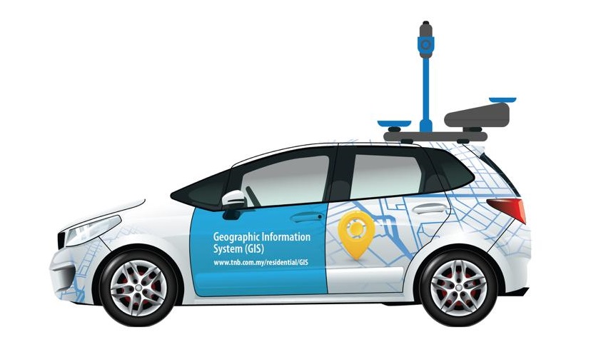
Street View Car
This streetcar view is outfitted with a camera system on top, and its portability enables us to gather images while maneuvering through locations that accessible by car. The system includes a single sensor that contains lasers oriented to cover roadside features up to 100 meters away.
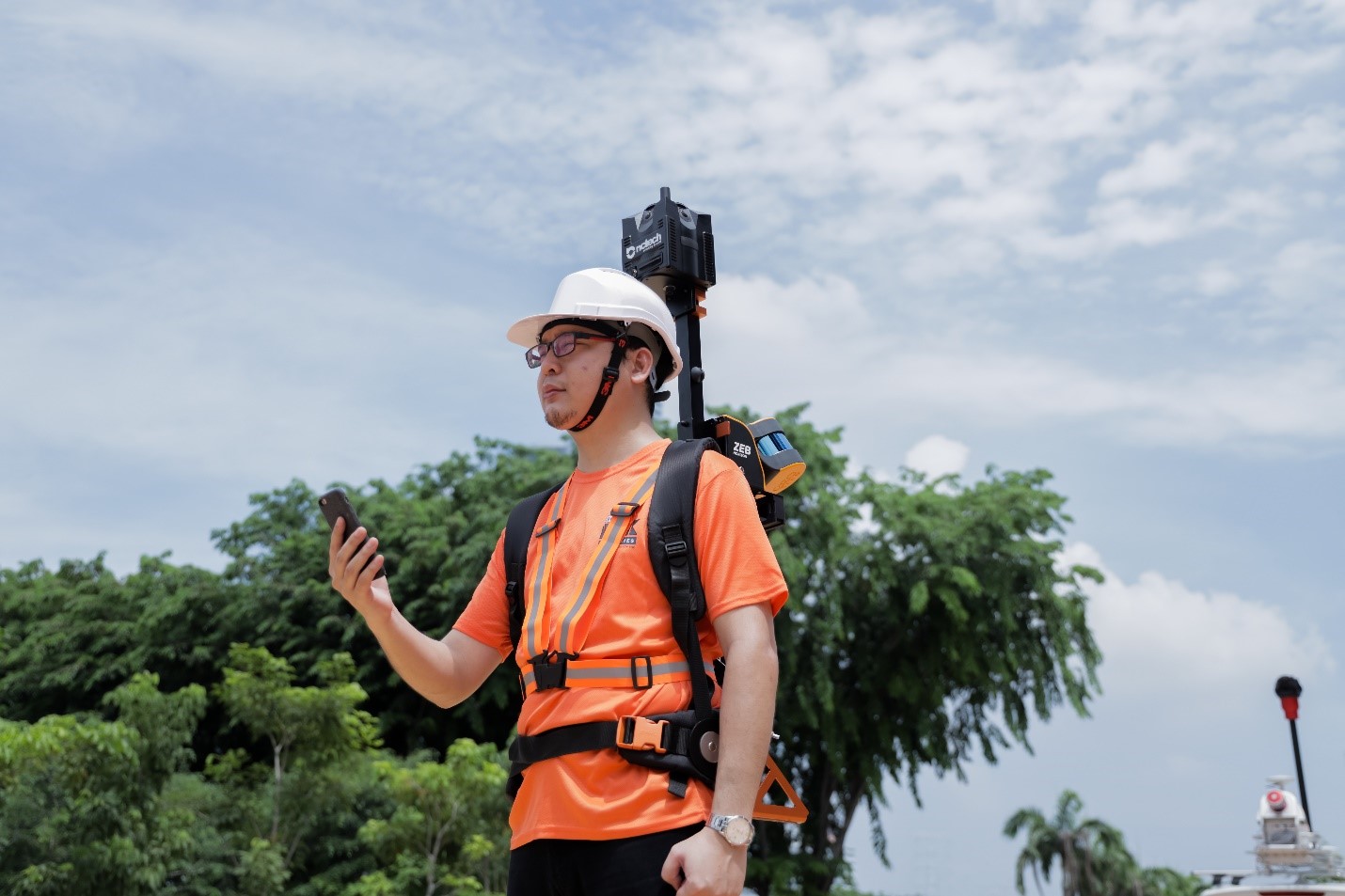
The back pack camera enables to capture features assets such as poles, street lamps, overhead lines, house meters and more. This wearable backpack is outfitted with a camera system on top, and its portability enables us to gather images while maneuvering through tight, narrow spaces or locations only accessible by foot such as rural areas.
XGUIDE DURING DATA COLLECTION IN YOUR AREA
Our authorised contractors will wear the wearable backpack that is outfitted with a camera system on top.
- Meter capturing at customer premise will only take few minutes
- An adult is required to be at home to allow access to view your meter only
- Our authorised contractors will be dressed in orange colored t-shirt labeled “Kontraktor TNB” and identify themselves with a photo identification ID.
- No personal information will be collected at customer premise
|
In view of the current situation relating to coronavirus (COVID-19), we want to reassure you that we’re taking all necessary measures to help ensure the safety of customers, our employees, and the people they may meet as part of their work activities. We assure you all authorised contractors will follow the guidelines by the Ministry of Health Malaysia such as avoiding close contact with you and using hand sanitizers regularly. |
FAQ
1. I saw a TNB contractor vehicle with a camera on top of the vehicle entering my residential area. Are they really TNB contractors?
Yes, they are TNB contractors.
2. How do I make sure the contractor is a contractor appointed by TNB?
You can check the TNB contractor card used by our contractor for verification purposes and they also wear an orange colored t-shirt labeled “Kontraktor TNB”.
The following is a list of contractors appointed for TNB's asset data collection:
| No. | Vendor | Area |
| 1. | GEOINFO SERVICES SDN. BHD. | Kuala Selangor & Sg. Besar |
| 2. | ANTARAGRAFIK SYSTEMS SDN. BHD. | Sg. Buloh, Bukit Kiara, TTDI, Bdr Sri Damansara, Bandar Manjalara, Chow Kit |
| 3. | TULIP RESOURCES SDN. BHD. | Banting & Sepang |
| 4. | MAP2U SDN. BHD. | Rawang |
| 5. | DR. NIK & ASSOCIATES SDN. BHD. | Bukit Jalil, Cheras, Sg. Besi, Sri Petaling, Tmn OUG, Kerinchi, Pantai Dalam, Bdr Tun Razak |
| 6. | DATA-SPEAKS (M) SDN. BHD. | Pusat Bandaraya, Bkt Bintang, KLCC, Ampang, Tmn Desa, Ulu Kelang, Bkt Antarabangsa, Pandan Indah |
| 7. | REDPLANET SOLUTIONS (M) SDN. BHD. | Titiwangsa, Setiawangsa, Wangsa Maju, Melawati, Gombak, Sentul, Batu Caves, Selayang |
| 8. | SCIENOTECH SDN.BHD. | Melaka Timur |
| 9. | RS & GIS CONSULTANCY SDN. BHD. | Melaka Barat |
| 10. | AEROSYNERGY SOLUTIONS SDN. BHD. | Bangi Timur |
| 11. | SPATIALWORKS SDN. BHD. | Bangi Barat |
| 12. | NSC GLOBALTECH SDN BHD | Kulai Jaya |
| 13. | ARTANIS CLOUD SDN. BHD. | Johor Bahru North |
| 14. | TRESDATA SDN. BHD. | Pasir Gudang |
| 15. | INNOVATION ASSOCIATES CONSULTING SDN. BHD. | Muar |
| 16. | ACiS TECHNOLOGY SDN. BHD. | Bayan Baru/ Nibong Tebal |
| 17. | DYNAMIC INTELLECT SDN. BHD. | Batu Pahat |
| 18. | STRATO SOLUTIONS SDN. BHD. | Tangkak/ Segamat |
| 19. | COMCENTRIC SOLUTIONS SDN. BHD. | Johor Jaya |
| 20. | INSPILOGIX SDN. BHD. | Kluang/ Mersing |
| 21. | GROUND DATA SOLUTIONS R&D SDN. BHD. | Kota Tinggi |
| 22. | MNJ TERAS SDN. BHD. | Johor Bahru South |
| 23. | PLISCA (M) SDN. BHD. | Bertam/ Butterworth |
| 24. | SETIA GEOSOLUTION SDN. BHD. | Pulau Pinang |
| 25. | I-MPV SYSTEM SDN. BHD. | Seberang Jaya/ Bukit Mertajam |
3. What are they doing?
They are mapping TNB's assets in digital form using photos of assets such as electric poles, street lamps, tops, fuse boxes (black box) on poles and more.
4. Why would someone put on a bag pack with a camera come near to my house?
They are TNB contractors who are also mapping assets for difficult-to-access areas. Photo-mapping of assets such as poles, street lamps, overhead lines, house meters and more.
5. My home area is my privacy. Is it okay if I don't allow my meter picture to be taken?
Our contractor has an approved permit from the Geospatial Defense Division (BGSP), Department of Survey and Mapping Malaysia (JUPEM) for TNB asset data collection work. The electric meter in your house is also an asset of TNB. Our contractor will only take photo of your meter for the purpose of digitally verifying and mapping assets.
6. What is the difference between assets mapping using drone vs mobile mapping?
Here are the differences in asset mapping using drone vs mobile mapping:
| Drone | Mobile Mapping |
| Asset mapping in top view | Asset mapping in ground / road surface view |
| Unable to retrieve pole no. and meter no. | Able to retrieve pole no. and meter no. |
| Suitable for aerial survey and maintenance work for TNB's overhead lines and transmission lines. Drones / UAVs are widely used in TNB Transmission / Grid division | Mobile mapping is expected to expedite the process of collecting data on sites involving assets such as electric poles, overhead lines, customers’ meters and reducing site visits |
7. What are the benefits do we gain from this mapping?
- Faster response time due to outages restoration time in the future
- Status and repair activities on site can be better informed to customers
- Customers can schedule daily activities by receiving a shutdown notice in advance
8. Is the data collected safe?
Yes, it is safe as it will only be used for internal purposes only.
9. I am not sure if its TNB authorized contractor, who can I call?
You can contact TNB Careline at 1-300-88-5454
X